
The echosounder is the most frequent tool for determining water depth and avoiding collisions with unseen undersea rocks, reefs, and other objects. The transducer for these sonar systems is normally located on the ship’s bottom. The transducer sends sound pulses right down into the sea.
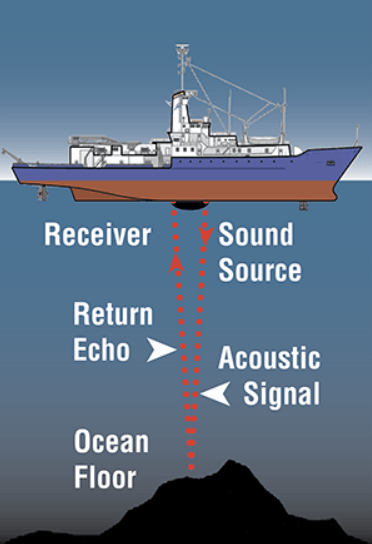
The sound bounces back to the transducer after bouncing off the seabed. The distance to the seafloor is calculated using the time it takes for sound to travel to the bottom and return. The speed of sound through water which is approx (about 1,500 meters per second) is used to estimate water depth.
Calculation for Echo sounder
The simple formula to use for this calculation is :
Distance = speed x time/2
Since the measured time will include both time i.e the sound travelling from transducer to the sea bed and then back from sea bed to the transducer. So to get the ideal result it is divided by 2.
The shallower the water depth and the higher the elevation of the sea floor, the faster the sound pulses return to the transducer from the ocean floor. As the ship moves along the surface, sound pulses are sent out on a regular basis, resulting in a line that depicts the depth of the water beneath the ship. Bathymetry maps of the survey area are created using this continuous depth data.
What is Echo Sounding ?
Echo sounding is a sort of sonar that transmits acoustic waves into water to estimate the depth of the water. The time interval between a pulse’s emission and return is recorded, and this information is utilized to calculate the depth of water and the speed of sound in the water at the time. This data is then often utilized for navigation or to obtain depths for charting.

Multibeam Echosounder
Multibeam Echo sounder is a relatively new and latest technology after ecosounder in order to cover more are in Echosounding. It is a new device that uses many sound beams at once to cover a broad fan-shaped area of the ocean floor instead of the small patch of seafloor that echo sounders cover. More than 100 transducers, grouped in precise geometrical patterns, are found in these multibeam systems, which send out a swath of sound that covers a distance on either side of the ship.
All of the signals which are sent, reach the seafloor at somewhat different times. Computers receive the signals and translate them to water depths, which are then automatically plotted as bathymetric maps. Multibeam surveys produce far more complicated data than single-beam surveys, allowing for higher resolution while also necessitating more sophisticated signal processing in order to comprehend the data.
Multibeam echosounder produce high-resolution all along the survey area . They can cover the whole seafloor as they collect extensive sounding data both along the ship’s track and between the track lines.
Topographical features on the bottom, such as sediment ridges, rock outcrops, shipwrecks, and underwater cables, are located using multibeam sonar. Ships also employ this technology to avoid regions where their vessels or gear would be endangered, to locate fishing grounds, and to carefully map the bottom. This technique can locate objects as small as one meter in length.
Echosounder has proved to be very beneficial for sea going vessels which helps in determining the actual depth of the sea. We have covered all the things related to echosounder in this article. Hope you enjoyed it.
Read About : How Steering Gear Works ?
Also Read : How Fresh Water is Produced on Ships ? Freshwater Generator
Suggested : Working of Centrifugal Pump
Check Out Other Important Topics
Home IC Engine Electrical Important PDFs Boilers Synergy Maritime Exam Naval Arch Interview Questions Difference Between Types of Pumps Types of Valves MEO Class 4 Auxiliary Machines